Rattlesnake Lake Recreation Area & Trails
The Rattlesnake Lake Recreation Area is a day-use area located outside the hydrologic boundaries of the Cedar River Municipal Watershed near North Bend. The lake is located near Interstate 90, exit 32, about 3 miles southeast of North Bend and about 35 miles east of Seattle. The recreation area includes the 111-acre lake, picnic areas, the Rattlesnake Ledge Trail, and parking access to miles of State Park and King County hiking, biking, and horse trails. The recreation area is owned and managed by Seattle Public Utilities as a non-development buffer to the protected municipal watershed lands. The watershed supplies 65% of the Seattle region's unfiltered drinking water to nearly 800,000 people. Rattlesnake Lake is not used for drinking water and is spring-fed by the nearby Cedar River.
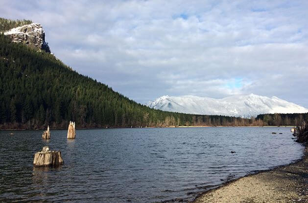
Rattlesnake Lake and Ledge
Rules and Regulations:
- Open dawn to dusk, year-round. Parking is free.
- NO camping or open fires. (Gas bbq's okay if used on non-flammable surface.)
- Private or exclusive events (gatherings, celebrations, weddings, etc.) of 30 or more people are prohibited.
- Unmanned Aerial Vehicles (UAV’s), such as Quadcopters, drones, and model airplanes are prohibited.
- Portable toilets and lakefront picnic areas. NO drinking water.
- Water is available at the Cedar River Watershed Education Center.
- Boat launch: Self-propelled and electric boat motors only.
- Swimming: NO life guards, swim at your own risk.
- Fishing: Year-round, Washington State selective gear rules apply.
- Hunting and gathering is prohibited.
- Absolutely NO fireworks.
- NO feeding wildlife.
- NO commercial activity.
Please take the "Leave No Trace" pledge:
- Pledge to keep Washington's trails beautiful! Rattlesnake Ledge Trail belongs to all of us.
- Respect wildlife. Observe them from a safe distance and pledge not to feed them and keep your pets on a leash.
- Dispose of waste (human, dog and trash) properly. Pledge to pack it in and pack it out.
- Preserve the wild experience. Pledge to help create a great trail culture that respects other trail users, yielding the trail and letting the sounds of nature prevail.
Rattlesnake Lake Trail
This lake trail is located on the southeast side of the lake and is a mix of barrier-free paved and packed gravel loop trails that access the lake, parking, and the Cedar River Watershed Education Center.
- Length: 3/4 mile to Cedar River Watershed Education Center
- Difficulty: Very easy
- Users: Foot, Bike, ADA Accessible
- Rattlesnake Lake Trail & Ledge Map (PDF)
Rattlesnake Ledge Trail and Rattlesnake Mountain Trail
Beginning at Rattlesnake Lake, the first 2-mile section to Rattlesnake Ledge Trail is one of the most popular hiking trails in the region. Expect to encounter many hikers and dogs on the trail and use extreme caution around exposed cliffs and steep drops. The Rattlesnake Mountain Trail is cooperatively maintained by Seattle Public Utilities, King County and Washington Department of Natural Resources with help from the Mountains to Sound Greenway Trust trail crews and volunteers. The Rattlesnake Mountain Trail continues west, gaining elevation, for 9 more miles to Snoqualmie Point Park. The Rattlesnake Mountain is also known as Rattlesnake Ridge on many maps.
- Conditions: Expect winter conditions through April. Be prepared and always carry the 10 Essentials. Be advised weekend trail use is heavy year-round and parking is limited at Rattlesnake Lake.
- Length: 2 miles to Ledge and 11 miles across Rattlesnake Mountain to Snoqualmie Point Park
- Difficulty: Moderate to Difficult
- Users: Foot only, No Fires, No camping
- Rattlesnake Lake Trail & Ledge Map (PDF)
- Rattlesnake Mountain Brochure & Map (PDF)
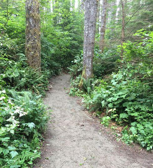
Rattlesnake Ledge Trail
Additional Area Trails
Palouse to Cascades State Park Trail
The Cedar Falls Trailhead at Rattlesnake Lake is the western portal to the Palouse to Cascades State Park Trail. After about 18 miles you reach the 2-mile-long Snoqualmie Pass tunnel. Bring flashlights and bike lights if you intend to travel into the tunnel. The tunnel trail section continues east to Hyak and then ends in 80 miles at the Columbia River. A Washington State Discover Pass is required at the Cedar Falls Trailhead. Check with Washington State Parks for current conditions.
- Conditions: Expect winter conditions through April and note that the tunnel is closed November 1st through May 1st.
- Length: 18 miles to Snoqualmie Pass Tunnel, 100 miles to Columbia River
- Difficulty: Easy to Moderate
- Users: Foot, Bike, Horse
- Palouse to Cascades State Park Trail Brochure (PDF)
Snoqualmie Valley Trail
This scenic King County regional trail and former railroad grade traverses from Rattlesnake Lake north through the cities of North Bend, Snoqualmie, Carnation and Duvall. For current conditions contact King County Parks.
- Length: 8 miles to North Bend, 31.5 miles to Duvall
- Difficulty: Easy
- Users: Foot, Bike, Horse
- Snoqualmie Valley Trail Map (PDF)
Cedar River Watershed Education Center
The nearby Cedar River Watershed Education Center located on Rattlesnake Lake's south shore offers visitors a chance to experience the watershed through exhibits, information, watershed tours, field trips and special events focused on Seattle's drinking water, history, wildlife and more. Enquire at the Center about room rentals, special event requests and permits for sporting events, races, community gatherings for 30 or more people, and film productions.
Contact the Center for information about trail conditions, watershed tours, and recreation area Special Events:
Cedar River Watershed Education Center
17905 Cedar Falls Road SE
North Bend, WA 98045
(206) 733-9421
CRWPrograms@seattle.gov